Tulum Ruins: Zama, the Maya City Facing the Caribbean
Explore Tulum, the Maya clifftop city on the Caribbean. History, temples, cenotes, practical tips and Mexico's most photographed beach.
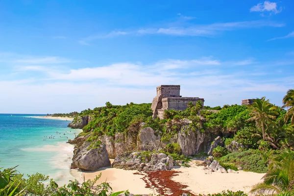
On the eastern coast of the Yucatan Peninsula, atop a limestone cliff that drops sharply into impossibly blue waters, stand the remains of a city the ancient Maya called Zama, the City of Dawn. Each morning, the first ray of sunlight to touch the coast would illuminate its white stucco walls, its temples painted red and blue, and the sails of trading canoes approaching from the horizon laden with jade, obsidian and salt. Today we know it as Tulum, a word that in Yucatec Maya means wall or enclosure, and it is the only Maya archaeological site built directly facing the Caribbean Sea.
Visiting Tulum is far more than walking through a collection of ancient stones. It is an immersion in the history of a civilization that mastered mathematics, astronomy and maritime trade centuries before Europeans arrived. And you experience it with the sound of waves as your soundtrack and the chance to end the day swimming at one of the most beautiful beaches on earth.
History of Tulum: from commercial splendor to silence
Tulum was founded around 564 AD, according to stelae found at the site, although most of the structures visible today date from the Late Postclassic period, between the 13th and 15th centuries. Unlike the great Classic Maya metropolises such as Tikal or Calakmul, which were abandoned centuries earlier, Tulum prospered precisely as those cities declined.
The key to its success was maritime trade. Situated at a strategic point on the Caribbean coast, Tulum served as the main port for the powerful inland city of Coba, located 44 kilometers away. Both cities were connected by a sacbe, a raised stone causeway covered in white limestone stucco that stretched through the jungle, part of a network of more than 50 white roads radiating from Coba. Along these routes traveled cargoes of turquoise from present-day New Mexico, obsidian from Guatemala, jade from Honduras, quetzal feathers, cacao, honey, salt and cotton textiles.
The city was protected on three sides by thick stone walls up to five meters high and six meters wide, while the fourth side was defended by the cliff and the sea itself. Between 1,000 and 1,600 people are estimated to have lived inside the walled enclosure, mostly from the ruling elite, priesthood and merchant classes, while the rest of the population resided outside the walls.
The Spanish first sighted Tulum in 1518, during Juan de Grijalva's expedition along the Yucatan coast. The chronicler Juan Diaz wrote in amazement that they had seen a city as large as Seville, with a very tall tower. That tower was El Castillo. Remarkably, the Maya continued to inhabit Tulum for about 70 years after first Spanish contact, until diseases like smallpox and measles, combined with colonial pressure, emptied the city by the end of the 16th century.
El Castillo: lighthouse, temple and symbol of Tulum
The most recognizable building at Tulum is El Castillo, a 7.5-meter-tall temple standing at the highest point of the cliff, commanding the panorama with the immensity of the Caribbean at its feet. Its silhouette appears in millions of photographs and has become one of Mexico's visual icons.
For decades El Castillo was believed to be exclusively a ceremonial temple. But in 1984, archaeologist Michael Creamer discovered that the two windows on the upper facade were precisely aligned to direct torchlight toward the coral reef protecting the coast. When fires were lit in both windows, approaching sailors could see the signals from several kilometers out to sea and, by following the angle of light, find the only safe opening in the barrier reef to reach the landing dock. In other words, El Castillo functioned as a lighthouse.
The upper temple facade is flanked by two columns shaped as feathered serpents, the symbol of Kukulcan, the supreme deity of the Postclassic Maya pantheon. Remnants of stucco masks depicting zoomorphic figures survive on the corners. Above the main entrance appears a relief of the Descending God, a figure plunging headfirst from the sky, a motif repeated throughout Tulum and one of the site's greatest enigmas.
The Descending God: bees, Venus and mystery
The image of the Descending God appears not only on El Castillo but also on the Temple of the Frescoes and in its own dedicated temple. This inverted figure, legs pointing upward and arms outstretched, has been interpreted in various ways by archaeologists. The most widely accepted theory identifies it as Ah Muzen Cab, the Maya god of bees and honey.
Beekeeping was a fundamental economic activity on the Yucatan Peninsula. The Maya raised the native stingless bee, Melipona beecheii, and its honey had medicinal, ceremonial and commercial uses. The Madrid Codex, one of the few surviving Maya books, depicts bees in exactly the diving posture seen at Tulum. Other researchers associate the Descending God with Venus, the morning star, whose appearance on the horizon the Maya linked to warfare and agricultural cycles.
The Temple of the Frescoes: astronomical observatory with murals
Beside El Castillo stands the Temple of the Frescoes, a two-level structure that functioned as an observatory for tracking the movement of the sun. Its windows are oriented so that sunlight enters at specific angles during the equinoxes and solstices, allowing priest-astronomers to calibrate the agricultural and ceremonial calendar with extraordinary precision.
What makes this building unique are the wall paintings still preserved on its interior surfaces. Dating from the 11th and 12th centuries, they depict supernatural beings, Maya deities and offerings. The blue, red and black pigments are still partially visible, testament to the artistic mastery of Maya painters. The exterior facade is decorated with stucco figures of the Descending God set into niches, reinforcing the omnipresence of this deity in Tulum's ritual life.
The Temple of the Frescoes is also the building that best showcases the East Coast architectural style, characterized by outward-leaning walls, narrow doorways with wooden lintels and rounded corners, features that distinguish Tulum from sites like Chichen Itza or Uxmal.
Tulum in the Maya network: Coba, Chichen Itza and beyond
To understand Tulum, it is essential to place it within the network of Maya cities that dominated the Yucatan Peninsula. Tulum was, above all, the port of Coba, an enormous city that at its peak may have housed 50,000 inhabitants and whose Nohoch Mul pyramid, at 42 meters, remains the tallest on the peninsula. The sacbeob, white raised causeways up to 10 meters wide and half a meter high, connected Coba not only to Tulum but to dozens of smaller cities, forming a commercial and political network comparable to Roman roads.
Further north, Chichen Itza had been the dominant power during the Terminal Classic period, and its influence on Tulum's architecture is evident in the feathered serpent imagery and the cult of Kukulcan. When Chichen Itza declined around the 13th century, coastal cities like Tulum and Mayapan took over political and commercial power. Tulum also maintained relationships with sites such as Xcaret, Xel-Ha and Tankah, all minor ports along the coast that formed a maritime logistics chain.
Tulum beach: where archaeology meets paradise
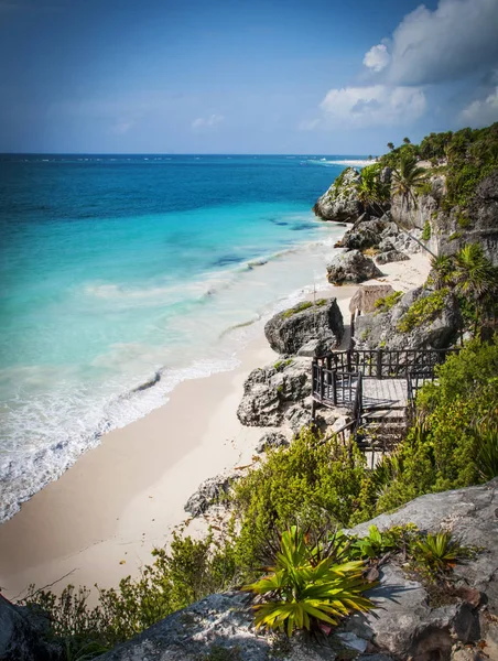
Few experiences in the world combine history and nature like descending the wooden stairs that connect the archaeological precinct to Tulum beach. A small cove of fine white sand, framed by the cliff and the ruins above, bathed in crystalline waters that shift from turquoise to emerald depending on the time of day.
Swimming is permitted here, and the sensation of floating in the Caribbean while gazing up at El Castillo silhouetted against the sky is unforgettable. The beach lies within the archaeological site, so access is included with your entrance ticket. It is advisable to wear a swimsuit under your clothes and bring biodegradable sunscreen, as conventional chemical products damage the nearby coral reef.
Nearby cenotes: Gran Cenote and Dos Ojos
No trip to Tulum is complete without visiting at least one of the cenotes that dot the region. Cenotes are limestone sinkholes filled with crystalline filtered water, connected to vast underground cave systems. For the ancient Maya, they were sacred entrances to Xibalba, the underworld, and beside them they performed ceremonies and deposited offerings.
Gran Cenote lies just 6 kilometers from the ruins, on the road toward Coba. It is a semi-open cenote, part of the Sac Actun cave system, the second longest in the world. Its aquamarine waters, stalactite and stalagmite formations, and the turtles swimming among visitors make it an extraordinary experience for both snorkeling and diving. It is the most popular cenote in the area, so arriving early is recommended.

Cenote Dos Ojos is located about 19 kilometers north of Tulum, between the town and Akumal. Its name comes from the two circular openings on the surface that look like a pair of eyes gazing at the sky. With 82 kilometers of explored passages, it forms part of the Sac Actun system and is one of the world's most prestigious cavern diving destinations. Underwater visibility exceeds 50 meters thanks to natural limestone filtration, and water temperature holds steady at 25 degrees year-round. Options exist for all levels: open swimming, snorkeling in the exposed area, or certified cavern diving.
Tulum town: tropical bohemia
A few minutes from the ruins stretches Tulum town, which over recent decades has undergone a radical transformation. What was once a quiet fishing village has become one of the most coveted destinations in the Mexican Caribbean, with a vibrant food, hotel and cultural scene.
The Tulum-Boca Paila highway, known as Beach Road, concentrates dozens of design boutique hotels, fusion cuisine restaurants, beach clubs with live music and artisan shops. Venues like Hartwood, which cooks exclusively with firewood and local produce, or Papaya Playa Project, with its full-moon parties by the sea, define the spirit of contemporary Tulum: a blend of sophistication and ease, of sunrise yoga and midday cenotes, of street tacos and craft cocktails.
The town center, more authentic and affordable than the beach zone, offers local taco stands, fruit shops and markets where everyday Mexican life flows on unbothered by tourism. It is a good base for travelers seeking a closer connection to the real country.
Practical information for visiting Tulum ruins
Hours: The archaeological site is open daily from 8:00 AM to 5:00 PM, with last entry at 3:30 PM. Arriving first thing in the morning is recommended to avoid both heat and crowds, which increase considerably from 10:00 AM when tour buses arrive from Cancun and Playa del Carmen.
Admission (2026): The total fee for international visitors is approximately 625 Mexican pesos, comprising the INAH ticket (210 pesos), CONANP conservation bracelet (120 pesos) and Jaguar National Park fee (295 pesos). Mexican residents or citizens pay around 360 pesos. Children under 13 enter free. Cash and credit cards are accepted.
Getting there: Tulum is 130 kilometers south of Cancun, roughly 1 hour 45 minutes by car on Highway 307. From Playa del Carmen, the distance drops to 65 kilometers and about 50 minutes. Frequent ADO buses run from both cities. Renting a car offers greater flexibility for combining the visit with cenotes and other sites.
Best season: The dry season runs from November to April, with pleasant temperatures of 24 to 28 degrees and lower rainfall. January and February offer the best balance of good weather and moderate crowds. Avoid Easter week and the last two weeks of December if you want tranquility.
What to bring: Biodegradable sunscreen, hat or cap, water, comfortable shoes for walking on uneven stone, swimsuit for the beach and cenotes, and a light towel. There is little shade inside the precinct, making hydration essential.
Recommended duration: Between 2 and 3 hours to explore the site at a relaxed pace, read the informational signs and go down to the beach. If combining with Gran Cenote or Dos Ojos, it is best to set aside a full half-day.
Tulum is far more than an archaeological site. It is the physical testimony of a civilization that could read the stars, master sea routes and build a city that, 800 years later, still inspires awe in every person who gazes from its clifftop. It is where ancient history and the natural beauty of the Caribbean meet effortlessly, and that is why it remains one of the most memorable destinations in all of Mexico.
Our 10-Day Riviera Maya Guide (EUR 9.99) includes a detailed day-by-day itinerary covering Tulum, Coba, Chichen Itza, secret cenotes, offline maps, local restaurants and tips for avoiding the crowds.
Comments
Get the best travel tips
Subscribe to the Omyguide blog and never miss an article.
No spam. Unsubscribe anytime.